Rescue Bronson was born a few years ago when the City decided to “improve” [for through motor traffic] Bronson north of the Queensway. Their plans did not include landscaping, traffic calming, fixing the jack rabbit stop-and-start flow or the frequent rapid lane changes. Pedestrians? Never heard of ’em. Cyclists — run ’em over til they go somewhere else.
Rescue Bronson had limited success in correcting the City’s mania to facilitate commuting to Pointe Gatineau. We got better landscaping. A signalized intersection at Arlington where the unmarked crossing was heavily used by cyclists and pedestrians. Cost of relocating the utility poles undid their proposed road widening. We got progressively better sidewalks in each of the three phases of reconstruction.
A city official observed to me, somewhat triumphantly, that “Bronson turned out all right”, meaning that our concerns were fear mongering. When I elicited from him the things that were “right” they were all the items we fought for. None of the triumphs were theirs. Sad and typical.
So now the engineers are shifting their focus to Bronson south of the Queensway, to the Canal. And Rescue Bronson has met with concerned Glebites to share some of what we learned. In preparation, I made a point to walk the section to see what problems could be easily remedied.
A major issue is the inability of pedestrians to cross Bronson between Carling and Fifth. I arrive at Third and Bronson every Monday evening on a walk home, and curse myself for arriving at that spot. I’ve gotta walk south a few blocks to Fifth, and then back north … or north to Carling, and walk along that particular hell-hole of a grossly overbuilt and underused road (what goofball engineer decided a single lane of traffic feeding off from Bronson onto Carling needed THREE receiving lanes (reduced a few years ago, at great effort, to two receiving lanes when a planter was installed near the corner).
But back to Third Avenue.
At Bronson.
Where I am still waiting for a break in traffic to cross the street at an unmarked crossing. Note: it is not jaywalking to cross the road. It is an intersection. It is not yet illegal in Ontario to cross the street. But prudence and survival take the upper hand — I am not yet ready for a Darwin award.
The City and OCTranspo think people should cross at Third. After all, the local bus stops are on both sides of the road, which means residents / transit users (remember those people, the ones at the supposed top of our transportation master plan priority list? Yeah, you forgot too) are required to cross Bronson at least once for every round trip by bus.
We all shook our heads when some lady in the southern USA got charged with child neglect for crossing the street at a bus stop when the “official” must-not-delay-motorists-for-even-one-second crossing was a mile away. In Ottawa, on Bronson, we substitute the neglect charge with a capital punishment lottery.
Saves on court costs.
The traffic on Bronson near Third moves in platoons, or waves. Just as the southbound wave lets up a bit, the northbound one arrives. That’s when the road isn’t filled with continuous stream of traffic with no breaks at all. And it moves remarkably fast. Kudos to the engineers for that success. They design a road for 60kmh to create a margin of safety when the (unobserved) speed limit is 50. They transfer the risk of motorist errors to cyclists and pedestrians, who are given no margin for error at all. And where even perfect pedestrian and cyclist behaviour is incredibly dangerous.
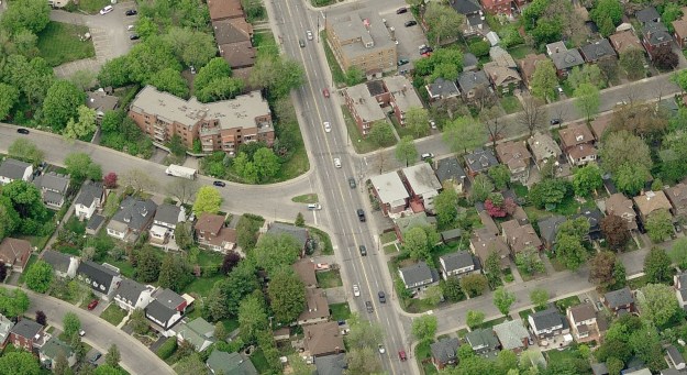
To reduce the speed of traffic on this section of Bronson, and to permit a pedestrian crossing at Third /Kippewa, lets look at this thought experiment. Examine the “before” picture again. Look how much asphalt there is a Kippewa (the broad street coming in from the left). Tons too much of it. Along a severely under-landscaped road.
If we introduce a deviation in the southbound lanes, if we split Bronson into two segments, one going north (just where it is) and one going south (the deviated lanes) then the road looks less like the freeway it was designed to imitate, and more like a street. Here’s a photoshop illustration:
Traffic moving in both directions perceives a narrower right of way. The large tree growing (oh, the magic of photoshop) in the centre island breaks up the freeway-like void. Some of that former Kippewa Sea of Asphalt has turned into greenery. With more thriving photoshop trees (we should get Adobe to plan our cities…).
If you position the island well, pedestrians could cross from the north sidewalk of Kippewa to the island, then cross to the south sidewalk of Third. A two stage crossing is still dangerous, but is much easier than having to cross all four lanes at once, where it is very difficult to correctly estimate the speed of traffic and its acceleration coming simultaneously from two directions.
The City would not permit an official crossing here unless there were traffic lights. So, put in half lights, ie ones that face Bronson only, leaving Kippewa and Third with stop signs. The lights would be pedestrian activated. Otherwise we will eventually run out of potential OCTranspo users, having run them all over on their way to the far side bus stop.
The engineers might howl. But then … maybe not. Because the island could be placed to prevent left turns onto Kippewa or Third, or from those streets turning left onto Bronson. Which would make the street safer for both types of motorists (banning most left turns comes just after banning right turns on red, in my wish list …).
If reluctant, the engineers will come up with fancy, super expensive, super complicated add ons to prevent the island from appearing. They’ll want 600′ of gentle taper, with painted warning lines, leading up to the island. Or want no trees, no shrubs, no nothing “to preserve visibility and enhance safety” (and freeway speed).
Funny enough, when they want to split traffic for something of their own, they have no problem with car-damaging splitting islands:
Now recall, this is a thought experiment. It isn’t a recommendation to build exactly as illustrated. It is to take a fresh look at the space along Bronson, to add to some greenery, to calm the traffic, to facilitate pedestrian safety, to enhance access to transit, and yes, to improve motorist safety. All from a simple traffic splitter.
It is up to the new members of Rescue Bronson (Glebe edition) to figure out what they want.
Trying looking from one picture to the other. Which layout do you prefer?


With reference to Arlington / Bronson: while I’m very glad they put that in, my beef as a cyclist is that 1) while there’s an the embedded signal activation strip, the eastbound one is fairly far from the curb (due to an adjacent storm water grate), so if one wants to trigger it there’s no way for right-on-red motorist to get past. And some of them honk at you to get out of “their way”. Leading to 2) one can sit on that strip for what feels like five minutes (though maybe it’s really only two) before it triggers.
They’re honking for you to get out of THE way. Ottawa needs more honkers!
Cool
Did you see this report from MapBox?
http://trafficways.org/talks/2014-12-05-gehl.pdf
A crossing island was added somewhat recently on Colonel By at Hartwell Locks to help pedestrians and bikes cross to Carleton. It works great – way faster and easier to cross, and it doesn’t take up a huge area. No traffic light needed (guess they got around needing one since it’s on NCC property?).