This is part iii of a series on downtown bus routes once the Confederation Line opens in 2018. Part i was on STO routes. Part ii was aimed at understanding what OC Transpo is trying to achieve with the new bus routes. I strongly advise readers re-read Part ii, the previous story, as it very much helps understand the new route maps.
First all, DO NOT STUDY the following route map. It is the May 2017 OC Transpo route map. It is almost impossible for anyone to figure out where individual bus routes run. And they have changed a lot of things on the routes. Many bus route numbers changed (for eg, the old 2 is shown as new 52, but in fact became 11, and its terminus moved from MacKenzie King to UOttawa).

So here is the Nov 2017 route map version, attached to the Albert-Slater transportation study now in progress, and available at the Nov open houses. But wait, DO NOT STUDY this map either, because it is outdated too …

The Albert-Slater study map shows the 85 going to Gatineau and using the loop in front of Terrasses de la Chaudiere, but newer maps show that loop taken off, perhaps due to the extensive construction and recladding/facelift of those Campeau-era red-brick-panel towers. And the map above still shows the old No 2 as a new 52 when it actually became 11.
So … break the suspense, what is the latest OC map? Here it comes, ta da! BUT DO NOT STUDY it. You will hurt your eyes trying to find your bus route …

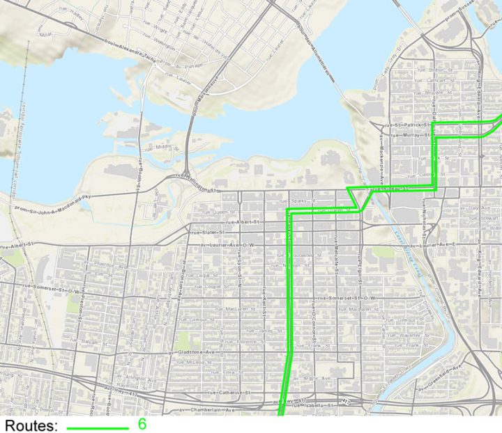
To save your eyeballs for something better (a nice nap, maybe) my colleague Richard Eade has kindly teased out each individual bus route and put it on a separate map, as best as we can figure it out.
Remember, this is a moving target. Routes are likely to change again between now and August 2018, and maybe again in 2023 when Phase 2 of the LRT is supposed to be opened by Mayor Watson. Nonetheless, if there are things you don’t like, you might want to point them out to OC Transpo.


Note that the route 85 no longer goes downtown. This is to reduce the number of buses in the downtown core. It also forces those users who might not otherwise use the Confederation Line LRT onto the LRT, inflating those ridership/popularity numbers. And with more exposure to the LRT, maybe some bus users will love it so much they make future living arrangements to take into account easy access to the LRT.
If someone was on the 85 eastbound, at rush hour, it might be better to get off at Carling Station, take the Trillium Line north to Bayview rather than sit in traffic on Preston, then transfer at Pimisi / LeBreton to take the Confederation Line east through to the downtown core. It will take a number of tries to see if the timing works out better …

Now, recall yesterday we discussed the Waller Loop at UOttawa. Here it is repeated:

And here is a version showing bus routes on it and the route, in red, of the underground LRT:

Note that the Routes 5, 11, 16, and 19 stop at Starbucks only on the southbound direction, and go around onto Nicolas for the northbound direction. There is (as of today) no north or westbound stop shown on Laurier or the Nicolas portions of the Loop. That block of Waller seems to be only for a southbound stop or storing buses before they depart on runs. So maybe students will be forced to walk to the Rideau Centre stops anyway. Is this good or bad?
_________________
Expect future route changes.
There isn’t time to go into the current bus numbers and how they change to the ones shown here. For example, the current 95 series becomes the 60’s heading over the Chaudiere Bridge (not to downtown anymore).
We owe a big debt of gratitude to Richard Eade for breaking out these maps and alerting us to some of the impacts of the changes.


Am I allowed to miss the number 2 yet? Because I’m certainly missing the part where the 2 got applied to some other higher priority bus route…
It’s interesting how the 2, serving the gentrified or gentrifying west end, got media nostalgia and a souvenir t-shirt, while the axing and renumbering of Vanier routes got… nothing.
To be fair, for most of its history the 2 actually went right down Montreal Rd through Vanier.
It stopping at Mackenzie King Bridge is a newish change.
Den: the No 2 moniker got applied to the public washrooms in the stations, err, no, got applied to the Trillium Line.
Why can’t all the downtown-originating, -terminating, or -transiting routes use Rideau Street OR Mackenzie King? One or the other. But this splitting of the downtown terminus, and forcing riders to “commit”, is effectively a massive reduction in frequency.
That’ll probably be pressure from the Rideau Center, the only real reason that mall exists and is successful is because people have to walk through it from Mackenzie King down to Rideau (or vice versa) to transfer buses. Iif they got rid of one or the other the mall would take a major hit.
Especially since they are already losing most of Gatineau.
For the current ongoing design process for repurposing of Albert-Slater-Mackenzie King bridge post LRT, the bus volumes moving between the bridge and the Waller-Nicholas loop are important contextual information. According to the info you show above, as far as I can tell the bus movement EB off Mackenzie bridge and straight to Waller involves the 11, 19, 16….maybe ~12 buses/hr = 1 bus every 5 minutes…..This compares to today where that movement is 180 buses/hr = 1 bus every 20 secs!.
For some people, it seems any buses is too many buses, which is such a backwards attitude.
If your starting and ending points are not on the Confederation Line, there will be too many transfers and the connections will be too inconvenient.